RF and Satellite Systems:
Automated Transient Satellite Systems
Independent Project
Summer 2020
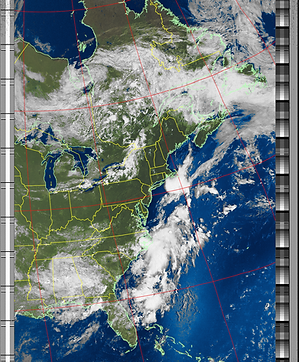
In collaboration with a partner, I spent the summer developing a portable and automated system to receive both APT and LRPT satellite signals, demodulate (and decode if necessary) , and generate the resulting near-real time image of the earth. The system was built to be cheap and portable, successfully taking data in the field for up to four days before its battery ran out.
A lot of bash scripting to coordinate command-line satellite software went into this project. A Raspberry Pi was used to make this a portable and headless system. I wrote a novel Python script to prioritize satellites that would give a better image, used when scheduling the capture of potentially conflicting passes. Unix systems and regular expressions were also learned through this project.
A physical prototype was also developed to house the Pi, its power source, and the software-defined radio. It was made to incorporate a variety of antennas that were tested and simulated (DCA and dipole antennas), and be portable and weather proof.
Focus was put on making this project inexpensive and accessible, potentially as a student or hobbyist project. A draft of a paper that is to be submitted can be found below, and a short talk I gave at the Convergence symposium can be found under the "talks and presentations" tab.
.png)

.png)
Article Draft